|
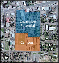
The aerial view above shows exactly where the “northern expansion” is located in relationship to the proposed campus.
The site is bounded by the Deuce to the north, 8th Street to the east, 6th Street to the west, and the campus site to the south.
Although there are a number of buildings currently in the area, much of it is dominated by vegetation, trees, and a steep slope that runs though the center. |
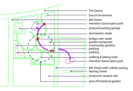 |
Immediately adjacent and directly to the north of the proposed campus site lies a series of relatively spacious, yet lightly developed, properties that offer tremendous potential for linking the campus and the new downtown expansion with the Deuce and the heavily-utilized business district of Show Low. The plan illustrated above is just one possible direction that this property might be developed; again, it is not a proposal, but it is an area that deserves close consideration as Show Low grows.
Note the parking garage near the Deuce that can serve the campus, downtown, and the business district. There is a swale (details on the next page) and two retention basins that facilitate catching storm water runoff and alleviate downtown flooding. The remainder of the area is composed of a botanical garden that could incorporate an outdoor restaurant, walking and biking paths, urban vegetable gardens, and recreational facilities.
Two main entries would link the campus to the northern parcels:
One entry would be near the northwest corner of the campus and would lead to the parking areas and the Community Gardens.
The second entry would originate near the center of the northern boundary of the campus site and would lead to the Botanical Gardens, the swale and retention basin, and the Deuce, providing a link to a potential new downtown shopping and business district along Huning Street. |